Go directly to content

Lofoten: Closes the fairway through Molldøra

Due to construction work to improve the fairway through Molldøra in Nordland, the fairway will be closed from 1 October at 10am to mid January.

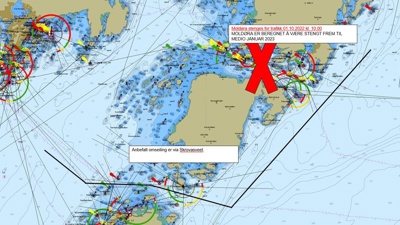
The Norwegian Coastal Administration (NCA) are improving the fairway through Molldøra and past Småskallan.

– In order to avoid accidents and dangerous situations for the seagoing traffic while dredging is in progress, it is important that all seafarers follows the changes in the sailing patterns. A detour via Skrovasveet is recommended, emphasizes project manager Magnus Rørvik in the NCA.

Molldøra and Småskallan are both located in Vågan municipality, where Molldøra is the strait between Lillemolla and Storemolla while Småskallan are underwater reefs located outside Kabelvåg.

– The project involves dredging the fairway through Molldøra and across Småskallan to increase the maritime safety, explains Rørvik.

The contractor for the project is Wasa Dredging Oy Ltd.

Contact

Senioringeniør

Magnus Rørvik /

Information

Charts 69; 73: a)
Deepening, Moldøra route closed: Precautionary area:
(1) 68° 13.93' N, 14° 46.01' E
(2) 68° 13.83' N, 14° 45.83' E
(3) 68° 13.49' N, 14° 47.52' E
(4) 68° 13.62' N, 14° 47.69' E

b) Temporary marking, Moldøra:
Light No.         –              Position          –               Type             –    Character
744810 Moldøra West 1 68° 13.95' N, 14° 45.71' E cardinal mark VQ (9) W 10s
744820 Moldøra West 2 68° 13.88' N, 14° 45.66' E cardinal mark VQ (9) W 10s
744830 Moldøra East 1 68° 13.62' N, 14° 47.32' E cardinal mark VQ (3) W 5s
744840 Moldøra East 2 68° 13.58' N, 14° 47.25' E cardinal mark VQ (3) W 5s

Charts 69; 73: c)
Temporary light buoys for recommended sailing route at Skrovasveet:
Light No.            –           Position               –             Character
744801 Rødholmen NE    68° 10.77' N, 14° 39.24' E       Iso G 2s
744802 Skotålbåan        68° 10.97' N, 14° 39.76' E        Iso R 2s
744803 Litj-Ramnøya     68° 10.76' N, 14° 41.44' E       Iso G 2s
744804 Hysskjæran       68° 10.87' N, 14° 42.25' E       Iso R 2s

Chart 73, 462: d) Deepening, Småskallene:
(1) 68° 12.32' N, 14° 31.12' E
(2) 68° 12.38' N, 14° 31.55' E

Note: Moldøra will be closed to traffic while dredging is in progress, and Skrovasveet is then the recommended route. Charts: 68, 69, 73, 462.

Temporary marking will be established at the easternmost Småskallen (-6m shallow).
Light No.                   –           Position                    –         Character
Light bouy BRB (temporary)    68º 12,38’ N 14º 31,60’ E      Fl W 2s

Furthermore, reference is made to ongoing information in ENC, EFS and Navigation Warnings.

Go to top