Go directly to content

Lighthouses and aids to navigation

Here you will find information about the lighthouse and beacon system in Norway

Alnes lighthouse.
Alnes lighthouse. Located on Godøy in Giske municipality, Møre og Romsdal. Photo: Olav Helge Matvik / The Norwegian Coastal Administration
Photo:Olav Helge Matvik/Kystverket

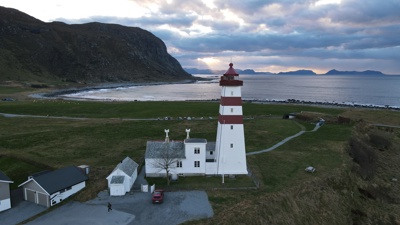
A lighthouse is briefly explained as a construction with lights, that guide ships and boats to areas where it is safe to sail along the coast and into ports when it is dark.

All along the Norwegian coast there is a comprehensive system of lighting sectors that define safe routes – where it is safe to travel. Normally you will sail in a white sector of one lighthouse, until you enter a new white sector of the next lighthouse.

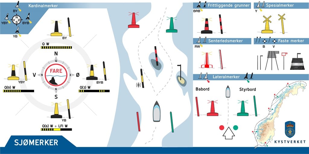
In combination with other types of beacons, the lighthouses form a complete system for safe navigation along the coast. Necessary information for using the lighthouse in navigation can be found in nautical charts and in lighthouse lists. Even in daylight, lighthouses can be used as an important landmark for safe navigation.

Throughout history, a total of over 200 manned lighthouses have been built in Norway, but there have never been more than 154 in operation at the same time. The technological development has made manned lighthouse services superfluous, and today all lighthouses are unmanned. Just over 100 of the lighthouses are still in operation as navigation installations.

Aids to navigation

It takes time to learn all the aids to navigation (AtoN), therefore our recommendation is to get familiar with the various types before embarking on a trip. Here is an overview of the most important types of aids to navigation:

  • Lateral marks: Shows the main direction of the marking (red around port - green around starboard)
  • Cardinal markings ("Kardinalmerker" in the illustration): Shows which side it is safe to pass a reef or a shallow.
  • Fixed marks ("Faste merker" in the illustration): Marks small cuts and grounds. The pointer points to safe waters.
  • Special marks ("Spesialmerker" in the illustration): Often used to mark areas with traffic restrictions - such as. bathing beach.
  • Isolated danger mark ("Frittliggende grunner" in the illustration): Navigable waters around the ground or hazard.
  • Safe water marks ("Senterledmerker" in the illustration): Defines the middle divide between two sailing guides.

Sjømerker.jpg

  • This is the standard for Norwegian coast markings

    The standard for floating navigation marks, buoys and pole beacons in Norwegian waters is in line with the IALA Maritime Buoyage System, which divides the world into two regions, A and B. Norway belongs to region A.
  • Transition to IALA Standard

    In the coming years, the Norwegian Coastal Administration will be reorganizing the sectors of around 1900 sector lights in compliance with the standard defined by IALA (International Association of Lighthouse Authorities).
Go to top