Go directly to content

Digital route service - routeinfo.no

At routeinfo.no mariners can download reference routes for navigation to ports, and get important route information and local regulations that apply to the route.

  • The digital route service routeinfo.no covers more than 500 digital routes for vessels calling at Norwegian ports.
  • There are four categories of routes: Inbound, outbound, between ports and coastal voyages
  • The routes are quality-assured for vessels up to 150 metres in length with a maximum 9-metre draught, with some exceptions.

The Norwegian Coastal Administration recommends that the reference routes be used when planning voyages to Norwegian ports. When choosing a route in routeinfo.no, you also get important information that applies to the specific route you have chosen:

  • Current regulations for relevant ports and quays
  • Distances
  • VHF channels in VTS areas is available at waypoints where routes enter their service areas

Practical use of digital route planning

From routeinfo.no, mariners can download routes free of charge for efficient and good route planning in advance of a voyage. By searching for a port, or clicking on the map, you can get to the individual sailing route, or download the package with all the sailing routes.

See video guides on how to use routeinfo here

The data files are available in the international standard for navigation systems, RTZ (www.cirm.org/RTZ) and can be uploaded to the vessel’s ECDIS/ECS. See the video guide on this page.

  • Important information about the voyage, such as sailing distances and local sailing regulations, is displayed when a route is selected.
  • In the files that are downloaded (RTZ), the VHF channel is located at waypoint where vessels enter the individual VHF zones connected to Vessel Traffic Service (VTS) centres.
  • Default turnradius 0.3 nautical miles has been used on the sailing routes that must be assessed against one's own vessel.
  • In a few places, the turnradius is smaller in order to ensure rapid changes in course.
  • Waypoints are appropriately placed to ensure safe and efficient sailing.

The Norwegian Coastal Administration encourages mariners to submit feedback about the service to help ensure that it is meeting mariners’ needs. Email feedback to:

  • On the routeinfo.no website, the routes are available with three different chart backgrounds, where users can zoom in on the different routes and areas. 
  • The map also shows where the individual local sailing provisions in the Maritime Traffic Regulations apply, and where quays and ports are located on the entire Norwegian coast (equivalent to the ports and quays in SafeSeaNet Norway).

The routes are also used by:

  • the pilotage service (in their Portable Pilot Unit – Njord Pilot), and
  • the Vessel Traffic Service (VTS) for vessel clearance (route exchange using SafeSeaNet Norway and the Norwegian Coastal Administration’s VTS system)

Read more about practical use in our FAQs

Published

Developed for mariners

The route service is free of charge, and has been developed to make voyages to Norwegian ports safer and easier. The service was launched on 18 September 2018 and will go nationwide in 2021.

Quality-assured routes

By providing reference routes that are quality assured by the Norwegian Coastal Administration’s pilotage service, Vessel Traffic Service, aids to navigation service, Pilotage Exemption Certificate Unit and the Norwegian Mapping Authority’s Hydrographic Service - the service helps to improve safety at sea.

Access to quality-assured routes and route information increases navigation safety and strengthens interaction on the bridges of vessels requiring the pilotage service and vessels with a Pilotage Exemption Certificate.

The route service facilitates more efficient and time-saving route planning, and can help ensure a more accurate time of arrival. The service also leads to environmental benefits and financial savings as a result of reduced fuel consumption.

Digital reference routes help ensure the following:

  • More efficient route planning for mariners
  • Vessels receive information that is specific to their route
  • Quality-assured routes and route information are more easily accessible for a vessel throughout the voyage from the port of departure to the destination
  • Safer and more efficient maritime transport

More digital and automated information

The service is part of the Norwegian Coastal Administration’s efforts to streamline and digitise maritime services aimed at supporting maritime transport. Integration of digital route planning and electronic charts is in line with e-navigation, which is a global strategy that recommends the digitised and automated exchange of information between ships and authorities.

The digital route service enables the automated distribution of nautical information to enhance transport safety for single voyages. Route information is a compilation of important and useful details about specific routes, and the service can therefore help prevent unsuitable routes being chosen due to a lack of crucial information.

The digital route service has been developed by Asplan Viak Internet.

Digital interfaces (API amd WMS)

In addition to the reference routes being available at Routeinfo.no, digital interfaces have been set up so that the routes can be included and further developed in other commercial and non-commercial navigation services. This practice is based on the Norwegian Licence for Open Government Data (NLOD).

This means that users of routeinfo.no can also come across these sailing routes in other services, and that various route planning tools can use the route information. Developers of navigation systems and services can subscribe to news about the digital interfaces, new versions, and updates. You can register here

Digital routes can be used in electronic chart systems (ECDIS/ECS), and are currently available in the PRIMAR chart catalogue. More details

An API (Application Programming Interface) solution is available to make it easier for providers of other navigation services to incorporate the Norwegian Coastal Administration’s digital route planning into their own systems. See link to API version 2

The reference routes for navigation can also be found in various GIS and map tools as a WMS service.

WMS Address: https://a3cloudmap.kystverket.no/wms.ashx
Name: layer_28
Title: Reference routes for navigation

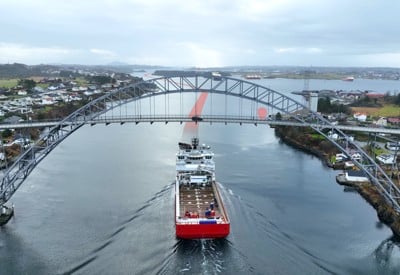
Development of products based on official routes that are quality assured by the Norwegian Coastal Administration can stimulate value creation and help ensure that even more navigators use the routes in the large range of services.

Commercial use of reference routes enables Norwegian routes to be viewed together with route information from other countries. It can give navigators a more comprehensive picture of the international route system from the port of departure to the destination, and make voyages safer and more efficient, as well as reduce fuel consumption, leading to environmental benefits.

See the example from the Australian route service

  • Wave Forecast

    See forecast for selected fairways and areas on the Norwegian coast.

  • NAVAREA XIX Warnings

    Get updates on navigational warnings for the Norwegian Sea, the Greenland Sea and the western part of the Barents Sea.

Contact

Senioringeniør

John-Morten Klingsheim /
Go to top